In September 2024, Hurricane Helene made landfall as a Category 4 hurricane and quickly became the deadliest hurricane in the United States since Hurricane Katrina. It brought catastrophic flooding, storm surge, landslides, and tornadoes, resulting in more than 250 deaths and $78.7 billion in damages, which some estimate may rise to $110 billion. Areas of Western North Carolina and Eastern Tennessee were devastated by the rainfall it brought, and Southwest Virginia experienced significant flooding.
“Flooding is a growing issue across local communities,” said Celso Ferreira, who leads George Mason University’s Flood Hazards Research Lab. “It is one part of engineering that’s not well-solved. Communities want to understand and adapt to flood risk, but it’s expensive. If it were easy and cheap, it would already be solved. That’s where this idea came in—we thought, why not involve students? Not just teach them engineering but help them create useful products for these communities. Can we make a difference without a multimillion-dollar firm? Can we bridge the gap?”
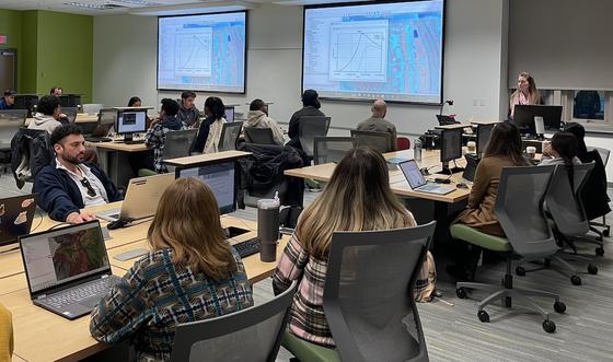
Ferreira recently redesigned the CEIE 445/645 Flood Hazard Engineering and Adaptation course to work with community partners to deliver real projects as part of the Institute for a Sustainable Earth’s (ISE’s) NSF Accelerating Research Translation (ART) Seed Translational Research Project (STRP) Program. He taught it for the first time in its new format in fall 2024 and plans to offer it again this fall.
In CEIE 445/645, a course for civil engineering students, undergraduate and graduate students work together on teams to develop flood risk maps and conduct analyses to help real clients in local communities improve their flood resilience. For some communities, especially smaller counties or tribes with fewer resources or no engineers on staff, this can provide critical data to help them address areas at higher risk of flooding.
The student teams used the recently developed Virginia Department of Conservation and Recreation (DCR) models, which provided ground elevation surface (topography), hydraulic friction values, and surface water infiltration values. This served as a common framework each project could be built upon.
During the first part of the semester, the students learned how to create models like those provided by Virginia DCR. Then, they worked with their clients to address individual case studies on flood mitigation.
“I think it’s transformational for the students,” Ferreira said. “I’m glad we’re able to do that. At the beginning, they wonder what they’ve gotten themselves into, but by then end, they’re proud of the projects they built. [This challenge] really captures their attention, and they get enthusiastic about it.”
Examples of student projects include:
-
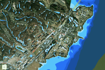
Pamunkey Reservation Flood Resiliency Plan - Located on a peninsula east of Richmond, the reservation is just slightly above sea level, increasing its risk of tidal and pluvial (surface water) flooding. The student team—Jacob Ryan Tomechko, Amanda Mullen, Paul Pacheco, Angela Haines-Perez, and Heriberto Perez—helped identify potential problem spots for roadway flooding including scenarios to address sea-level rise and significant storm events such as hurricanes.
-
Forwarding Roadway Resiliency Efforts in Mathews County – Matthews County is located on Virginia’s middle peninsula and is at risk of coastal and pluvial flooding due to its low-lying roadways. The student team—Matthew Cantos, Daniel Cardona, Mike DeCarlo, Eglal Salih, and Allyson Skahen—assessed which areas were at a higher risk of flooding due to poorly designed drainage ditches or other characteristics.
-
Flood Adaptive Roadways in Quantico, Virginia – Located in Prince William County, the Town of Quantico is near the Potomac River and Quantico Creek. The student team—Sebastian Galarza, Marcos Sanchez, Roberto Mejia, and Gabby Wade—helped the town assess roadway flooding scenarios to inform future evacuation efforts.
As part of their work, the student teams created ArcGIS storymaps for each project, available through the course website.
After the course, several students were hired as undergraduate research assistants to continue working on the projects so that they could take them beyond one semester’s work and provide the clients with more advanced projects. They are reviewing and enhancing all the projects to improve alignment with the clients’ requests and developing a standardized product that each client will receive.
One client was interested in using the student maps and analysis to assist with their proposal for funding to address these flooding issues. This is one way Ferreira sees clients being able to use the student projects. He explained that when communities apply for a grant to hire an engineering company for a project, they need to do preliminary analysis as part of this proposal. Many communities don’t have this capacity—they don’t have engineers to do preliminary analysis.
Ferreira worked with a graduate research assistant, two post-docs, and a PhD student over the summer of 2024 to redesign the course. “The funding from the ART program made it possible. It provided the resources to adapt the course in this way. It was key to have those resources, because it was a huge undertaking that couldn’t be done by one faculty member alone.”
The goal of the NSF ART program is to translate science from the university to real solutions for local communities that can help them better prepare for climate-related disasters. The ISE and Virginia Climate Center (VCC) are collaborating with the University of Kentucky and the Center for Climate Strategies on the NSF ART initiative to close this gap and help communities in Virginia improve their resilience.
CEIE 445/645 will be offered in the fall 2025 semester, and applications are still open for local communities to participate as clients.
Related News
- May 21, 2025
- George Mason civil engineering students are helping local communities improve their flood resilienceMay 8, 2025
- March 29, 2025
- July 8, 2024
- June 6, 2024